Pushing 3000 meters into the deep sea, China's self-developed marine seismic exploration equipment has achieved ultra deep water operations for the first time
People's Daily Online, Beijing, October 6 (Reporter Du Yanfei) A few days ago, in the 3000m ultra deepwater block in the the Pearl River Mouth Basin, the "Offshore Oil 720" deepwater geophysical exploration ship carried China's self-developed marine streamer seismic exploration acquisition equipment "Haijing" system, completed seismic exploration in ultra deepwater waters for the first time, and released China's first ultra deepwater 3D geological exploration map, marking new progress in the development of key core technical equipment for deepwater oil and gas exploration in China.The "Offshore Oil 720" geophysical exploration vessel is equipped with the "Sea Economy" system for ultra deep water exploration operations
People's Daily Online, Beijing, October 6 (Reporter Du Yanfei) A few days ago, in the 3000m ultra deepwater block in the the Pearl River Mouth Basin, the "Offshore Oil 720" deepwater geophysical exploration ship carried China's self-developed marine streamer seismic exploration acquisition equipment "Haijing" system, completed seismic exploration in ultra deepwater waters for the first time, and released China's first ultra deepwater 3D geological exploration map, marking new progress in the development of key core technical equipment for deepwater oil and gas exploration in China.

The "Offshore Oil 720" geophysical exploration vessel is equipped with the "Sea Economy" system for ultra deep water exploration operations. Respondent provided pictures
According to reports, during this operation, the "Offshore Oil 720" deep-water geophysical exploration vessel arranged 10 cables exceeding 8 kilometers in length from the "Sea Economy" system in sequence into the seawater according to the design requirements, forming a data acquisition network with an area equivalent to 1021 standard football fields. The sea surface cable acquisition operation was carried out along the route, and real-time seismic data acquisition of the source and detection points was completed, Accurately delineate the location of oil and gas reservoirs on the vast sea surface, assisting in high-quality exploration and development of deep-sea oil and gas resources.
Data shows that about 40% of China's proven oil and gas reserves are located in deep water areas. At the 2023 Work Promotion Conference on Vigorously Enhancing Oil and Gas Exploration and Development organized by the National Energy Administration, it was emphasized that we should strengthen deep-sea oil and gas exploration and development, and accelerate the construction of a maritime power.

The "Haijing" source control system enters the sea. Respondent provided pictures
The "14th Five Year Plan for Science and Technology Innovation in the Energy Field" points out that during the "14th Five Year Plan" period, it is necessary to build a manufacturing and testing platform for marine seismic acquisition equipment, apply core equipment such as marine seismic exploration system seismic streamers, control and positioning, comprehensive navigation, and air gun source control, and install three-dimensional seismic geophysical exploration ships to support the promotion and application of marine seismic exploration technology and equipment in deep-sea oil and gas exploration and development.
Industry insiders say that streamer seismic exploration technology is the most direct, economical, and efficient method in the world for detecting seabed geological structures. By using a complete set of towing equipment carried by a geophysical exploration ship to "plow" across the sea surface, seismic wave signals are used to achieve "CT" scanning of the seabed strata, thereby clearly identifying the oil and gas reservoirs on the seabed.

The "Haijing" streamer positioning control system is adjusting the cable depth. Respondent provided pictures
It is reported that "Haijing" is the first complete set of acquisition equipment for streamer mode seismic exploration independently developed and manufactured in China. It is composed of various equipment systems such as source control, streamer acquisition, comprehensive navigation, and positioning and control. It has the ability to collect ultra-low frequency signals at 2 Hz, improving the resolution of seismic data. Compared with imported equipment, the seismic data collected by "Haijing" has a higher recognition rate, and can accurately depict the complex geological structure of 10000 meters of strata through a water depth of 3000 meters. The overall performance of the equipment meets the current requirements for offshore oil exploration.
Since its production in September 2022, "Haijing" has gone through various operational methods, including conventional seismic acquisition, high-density continuous acquisition, and high coverage rolling acquisition. It has successfully completed three-dimensional seismic exploration of a total of 3935 square kilometers of sea area in four work areas, and has achieved product finalization and industrial production. It has the full industry chain capabilities of research and development, manufacturing, and service, and has established a complete industrial manufacturing system.
Disclaimer: The content of this article is sourced from the internet. The copyright of the text, images, and other materials belongs to the original author. The platform reprints the materials for the purpose of conveying more information. The content of the article is for reference and learning only, and should not be used for commercial purposes. If it infringes on your legitimate rights and interests, please contact us promptly and we will handle it as soon as possible! We respect copyright and are committed to protecting it. Thank you for sharing.(Email:[email protected])
Guess you like
-
-

Don't Overspend on These 4 Home Appliances: A Guide to Smart Consumption
-
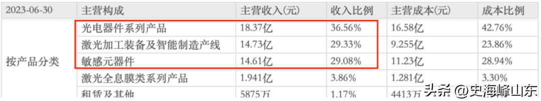
A Comprehensive Analysis of Huagong Technology: A Leader in Laser Welding for AskM9 and Beyond
-

-

Headline: Top Livestreaming Hosts Step Back from E-commerce as Industry Faces Shake-Up
-

-
-

The Rise of Hebei E-commerce: How a Low-Price Strategy Revolutionized the Market
-

The Rise and Fall of The Body Shop: A Cautionary Tale of Innovation and Adaptation
-
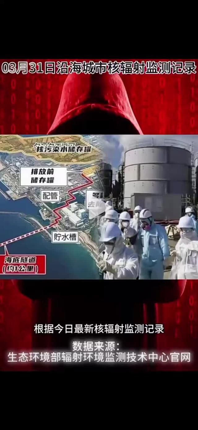
Nuclear Radiation Threat: Coastal Cities Face Grim Challenge
-

The Metamorphosis of Huawei's Board of Directors: An Eight-Year Journey
-

-

Connect Your Phone to Highway Surveillance Cameras to Monitor Traffic in Real Time
-

Brightmore Pinduoduo Vertical Farming Challenge: Advancing Innovation in Container-Based Cultivation
-

DingTalk AI Assistant Upgrade: Multi-Modality, Long Text, and RPA Empowering Work and Productivity
-

Taobao Invests Heavily in Content E-commerce With 100 Billion Yuan
-

WeChat and Douyin Crack Down on Illegal Plug-ins and AI Virtual Characters to Protect User Security
-

Yadea Cocoa: An Innovative E-Bike Designed for Urban Commuting
-

Xiaomi's Newest Leaders: Three Key Executives Shaping the Industry
-